Scandinavian Mountains over 2000 metres - James Baxter
Areas › Visbretind Massif › Walking Routes › Vi.1
| Vi.1 | Leirvassbu Lodge to Spiterstulen lodge |
|---|---|
| 5 hours / 16km 120m |
A well marked and obvious path in the summer and a marked ski route in the winter/spring season. |
This path is one of the major thoroughfares of Jotunheimen and is marked accordingly.
From Leirvassbu lodge the route initially goes round the north shore of Leirvatnet lake across stony tundra. After a km, at the north end of the lake, the path leaves the shoreline and starts to head east towards the deep valley between the mountains of Kyrkja and Tverrbytthornet gently climbing across the tundra for another km until you get to the westernmost of a series of tarns.
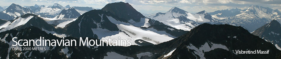
From here the terrain for the next 2km becomes much more stony and there are frequent boulderfields to cross as you skirt the northern shores of the four tarns in the narrowest part of the deep valley called Kyrkjeglupen. After the fourth and last tarn, called Panna, the valley starts to open out again and the terrain returns to pleasant tundra. From this vantage point Kyrkja looks like the church spire it is named after and Visbretind and its tumbling glacier looks very spectacular.
Just beyond this last tarn is the shallow watershed and a gentle slope down into the open grassy bowl where bubbling brooks, which the headwaters of the Visa river, start to congregate. Just before you cross the silty glacial stream flowing down from the Visbreen glacier to the south is the unmarked junction with the cross country, and unmarked, route Vi.2 heads off to the south east.
When you get to the glacial stream jump it. The path now bears north east and follows the east bank of the infant Visa river. After a km you reach another stream emerging from Semelholet which again has to be crossed on stepping stones. Here there are great views into the wild corrie of Tverrbytnet.
The good path continues across pleasant easy terrain for another 3 km down the east side of the river until you reach another stream, Urdadalsbekken, which is again crossed over stepping stones. There is often a herd of reindeer in the vicinity as they head from one grazing area to another in the side valleys. After this stream crossing the path continues down the stony meadows on east side of the growing Visa river for another 3 km on an easy path until you get to a glacial torrent, the Heillstuguåi.
Fortunately the two arms of this torrent are bridged with log bridges. The old crossing point is ½ km to the east where the torrent crashes over a cascade in a narrow gorge. The final 4 km are surprisingly long. The path becomes slightly rocky as it starts to head down through the willow scrub. There is the odd small stream to jump, and a few boggy areas, as you head gently down but generally the constructed path is good.
About half way down this last section Spiterstulen appears, but it still takes ½ hour to reach it. There are magnificent views to the north west on this final ½ hour up to broken snout of Svellsnosbreen glacier and the highest mountains in Scandinavia surrounding it.
In the winter/spring ski season the ski route roughly follows the summer path except the ski route goes over the frozen lakes. This ski route is marked with twig poles sometime before the Easter holiday and onwards.