Scandinavian Mountains over 2000 metres - James Baxter
Areas › Memuru Veo Massif › 11.6 Austre Memurutind (2301m)
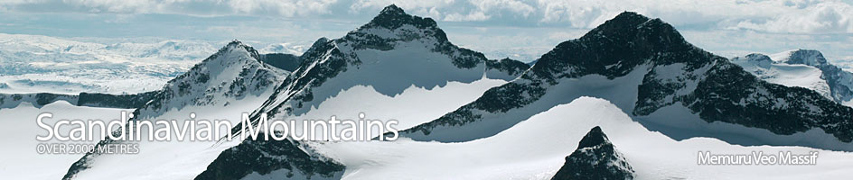
Austre Memurutind, 2301m, is a pyramid shaped mountain almost entirely surrounded by glacier. It is one of the least accessible mountain in the entire Jotunheimen and was only climbed for the first time in 1939. Austre Memurutind is one of many mountains and peaks on a huge horseshoe ridge of mountains which surrounds the glaciated drainage area of the Muru river, which drains the entire southern half of the Memuru-Veo massif.
| The Route from Memurubu Lodge | |
|---|---|
      |
|
From Memurubu lodge the path follows the north side of the Muru River. It is imperative to be on the north side as it is not possible to cross this river higher up. This well defined path rises up through verdant and flower-filled forests for 3 km before emerging onto a broad river valley for a further 5 km. This broader area is also quite fertile and it is not unusual to encounter a herd of reindeer grazing here. During these 8 km the ascent is quite gentle and the terrain only rises 400m altogether.
After 8 km the 250m cliffs of Reinstind are clearly visible 1 km away in the west. At this point a path leaves the main valley and heads north east up the Surtningssuibekken stream. This is the path up Surtningssui and should not be taken. Instead continue north up the Muru river for a further two km across less and less meadow and more and more moraine. This moraine wastescape continues for a further two km veering to the north east and despite the slow progress should be followed to the base of the scree slopes on the south west side of the upper Austre Memurubreen glacier. Rather than traverse across these scree slopes head straight up them towards the summit of Nørdre Blåbrehøi where after one km the scree, at last, becomes much more stable and the gradient eases. This is about 4½ hours from Memurubu lodge.
From Nørdre Blåbrehøi the character of the walk changes completely as you go north. There is now an broad ridge with excellent views over a steep drop to large glaciers on the east side. The demanding moraine and scree slopes are replaced by stable rock which one can saunter along appreciating the view. After 1½km and an shallow saddle the final slopes up to Sørvestre Styggehøbretind is easy, but the very final section to the summit is out on a very exposed arête and one cannot get to this summit without climbing and protection as it is grade IV. The traverse along the ¼ km jagged arête from this summit to Søraustre Styggehøbretind is also climbing of grade III.
From below the summit of Sørvestre Styggehøbretind there is an pleasant descent to the Styggehøbreskard saddle with the glacier on the north side and then a simple gradient up to Søre Veotind, which is the highest mountain in this cluster of peaks, and is in its own right a "Scandinavian mountain over 2000m". From here the ridge to the north and the impressive peak of Store Veotind is spectacular but the route is blocked by a substantial overhang just a short distance from the mountains' summit.
The final section along the ridge to Austre Memurutind involves an easy descent of 150m over one km down the west ridge of Søre Veotind. Initially the ridge is quite broad but narrows to a gentle arête at the lowest point. As the arête rises towards Austre Memurutind it encounters a crag which although somewhat airy does not present any problems to traverse. Some 200 metres after this crag the arête is covered in a glacier which is unavoidable as it covers the entire arête. This glacier/snowfield has a crest which is about 25 degrees for 150 to 300 metres depending on the time of year. In the spring or early summer stiff boots and an ice axe may suffice on the snowfield, but in July to September crampons are essential as the bare ice is exposed. From the top of this glacier it is a short easy scramble up to the summit itself.
The descent is by the same long route. If the party has moderate glacial experience and full glacial equipment it is possible to make a descent down the reasonably steep north ridge and onto the crevassed Veobreen glacier which can then be followed to it snout and on to Glitterheim lodge. Alternatively the steep west ridge can be descended, which involves a 20 metre abseil, down to the Memuruskard saddle. From this saddle the party can then descend, or abseil, the short ice/scree mix for 25 metres to reach the crevassed Austre Memurubreen glacier. This glacier can then be followed to it snout and the moraine wastescape of the upper Muru valley and on to Memurubu lodge.
For the really fit this tour can be combined with an ascent up Surtningsui also. Ascend Surtningsui (see separate page for details) and from the summit descent the easy and shallow north west ridge for 2km to a saddle and then easily up to the peak of Søre Blåbrehøi. From this peak continue the easy ridge north for another 1½km down and up past another saddle to the peak of Nørdre Blåbrehøi and continue as described above. This will add another 1½ hours if the return is by the normal route described above in reverse.