Scandinavian Mountains over 2000 metres - James Baxter
Areas › Stølsnos Massif › 2.1 Stølsnostind (2074m)
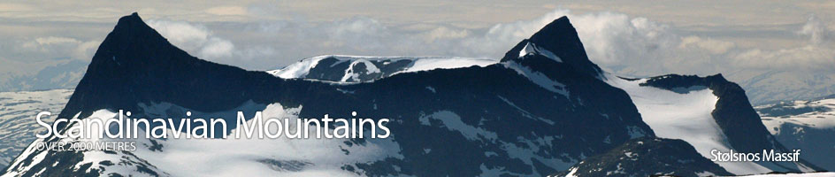
Stølsnostind, 2074m, Is the highest of the 3 mountains in the Stølsnos Massif. W.C Slingsby described it as "The king of the Koldedal mountains" and said it was one of the most enjoyable mountains he had climbed.
| The Route from Koldedalshytte | |
|---|---|
      |
|
From the private cabin cross the sluice over a torrent emerging from under the mountain and follow the north shore of Koldedalsvatnet Lake for one km until its western tip. From here climb the gentle gradient for another one km until the small lake at 1291m is reached. This lake is passed on the north side where a weak path initially goes over some slabs then levels out to at about 10 m over the lake until a steep snow bank is reached.
This snow bank extends right down to the water. It can either be crossed just above the waters edge or much higher up. A ice axe and solid footwear is necessary for this snow bank as a slip will mean a cold and dangerous swim amongst cluttered icebergs. After this short obstacle it is another 200 easy metres to the end of the lake.
 From the end of the upper lake descend down to the lower lake. Do not try and maintain height as you will end up on a huge ledge and have to backtrack. There is a slight path about 10 metres above the waters edge again on the south side. In about three places the path has been obliterated by rock falls, making it necessary to navigate through large scree.
After about a km, or 2/3 of the way down the lake, a tumbling stream plunges down the south side of the valley and enters the lake. As you approach this stream start to head up the south side and cross the stream, going about 150 metres to the west of the stream. Eventually the scree gives way to bare rock and the gradient steepens.
This section up the bare rock is not as difficult as it looks when the rock is dry. In the wet however, certain sections could be treacherous and slippery. Make for a obvious ledge which heads up and east towards the tumbling stream again. Follow this ledge up and as you approach the stream start to head straight up again picking a variety of routes across the bare rock.
Eventually the gradient of 40 degrees starts to ease off and the going become easy again. Continue on the west side until it flattens out into small valley with the glacier at the north end sliding into it and the stream flowing out from under it. It should be possible to cross the stream up here, either by stepping stones or a snow bridge.
 From the east side of this flat valley make for the glacier and start to head just east of north up the very east of it tongue keeping close to the rock. Once you have climbed a hundred metres the gradient eases and it now necessary to turn east to avoid going onto the main glacier. From here the buttress at the start of the west ridge of Falketind becomes visible.
If you make a bee-line for the bottom of the crags on the north side of this buttress you will pass harmless snowfields on the southern edge of the glacier and avoid the crevasses ½ km to the north. At the bottom of the crags hug the rock as closely as possible climbing quite steeply until you are past this buttress. It is then safe to head due east crossing a bowl on the north side of the west ridge, until you arrive near the bottom of the north ridge of Falketind, and can look over a vertical drop down to the Falkbreen glacier below.
From this position at the bottom of the north ridge of Falketind it is only a short distance to climb this famous and historic peak and it would be criminal not to take the opportunity. For a route description see the Falketind page.
The route to Stølsnostind now follows the long ridge to the north east. Initially there is a slight descent to the saddle between Falketind and East Stølsnostind, ( Ø-1), 2001m. From here there is a spectacular one km saunter along the ridge in a north west direction to a small knoll. The views along this section are stunning and the going very easy. Stølsnostind itself looks very foreboding from here, but fear not. From the small knoll there is a small drop to a saddle and then a short climb up to Ø-1, 2001m. There is a snow bank on the north side of the ridge on this ascent, but there is a glacier under it with a couple of big crevasses on the crest, so keep to the scree on the ridge or on the very south edge of the snow.
The descent down to the saddle between Stølsnostind and Ø-1, 2001m, is reasonably straightforward. There is a 5 metre crag near the top of the descent and this can be avoided on the south side. At the bottom of this crag is a slab which will be slippery when wet. The rest of the descent is an unproblematic but enjoyable scramble down to the saddle. At the saddle the glacier on the north side comes right up to the saddle itself.
From the saddle the daunting ascent starts. As it turns out the most challenging section is about 50m up from the saddle and it is no more than an interesting, but easy scramble. The route for this section initially goes up the crest, but after 25m veers to the north side and ascends a small gully. From the top of this gully there is a further 20 minutes of very enjoyable easy scrambling up the crest. There are a couple of sections that are fun before the gradient eases and the summit is reached. It is easy to see why W.C. Slingsby described this as one enjoyable mountains he had ever climbed. If the enjoyable ascent wasn't enough the view over to Hurrungane is the best I have seen. All the peaks rise uninterrupted from the perfect U-shaped, Shangri-la, alpine meadow valleys, which pour their foaming streams into the huge chasm of Utledalen Valley.
The return is by the same route which is the only route if glacier crossings are to be avoided. Although it looks long it is only 1 ½ hours from the summit back to the bottom of the north ridge with Falketind and a further ½ back to the top of the bare rock section. Alternatively, with glacier crossing experience and equipment it is possible to descend the glaciers on either the north or south side of the saddle between Stølsnostind and Ø-1, 2001m or descend to Falkebreen via the 'Pionerruta'. All these 3 routes are described as alternative routes.