Scandinavian Mountains over 2000 metres - James Baxter
Areas › Hurrungane › 1.8 Soleibotntind (2083m)
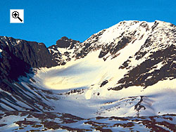
Store Soleibotntind, 2083m, is the most westerly of all the Hurrungane mountains. It still retains the very alpine character found throughout this area, and 2 of the 3 ridges are sharp jagged arêtes. The third ridge, however, is surprisingly gentle. The view from the summit of Store Soleibotntind is generally considered to be one of the best in Hurrungane.
| The Route from Turtagrø Hotel | |
|---|---|
      |
|
From Turtagrø hotel take the Turtagrø-Årdal road for 9 km over Berdalsfjellet and then down for a km further to the small bridge where the road goes over the Tverrelvi stream, and where it is possible to park. Follow the south side of the stream up east for ½ km, then leave the stream and veer south for a ½ km keeping to the east of a ridge which is starting to form. After this second ½ km you should come across a small shallow tarn at about 1335m elevation. Follow the stream, which is still the Tverrelvi, east and then south for a another ½ km until you get to the west end of a larger tarn erroneously marked on the map as 512m, but actually about 1435m elevation.
 From the west end of this lake head south up a stony spur which climbs and veers south east up onto a shoulder, called Bukkanosi, on the main west ridge. Continue up passing slightly to the north of knoll 1674m (where there is a large cairn) until you get to the bottom of the steeper section. If making a spring ski ascent this is probably the place to leave skis as the steeper ridge is often poorly covered in snow.
The steeper section of the ridge is not marked but the route goes straight up the stony ridge for a sustained climb of nearly an hour. During this ascent try and keep to the centre of the ridge and veer to the south side as you approach a steeper rocky outcrop towards the top. Weave through this steep small outcrop to gain a much easier gradient beyond it and then after another 200 metres a cairn on a false summit.
Between the cairn on the false summit there is an easy short ½ km of stony ground across the flattish summit dome to reach the main summit. In the spring and early summer there are large cornices on the north side of this summit area so keep a healthy distance from the edge.
 The Return

The return is by the same route unless you are experienced and prepared (rope, crampons and ice-axe) to go down the north or south east ridges.
Although Store Soleibotntind can easily be climbed in the spring via this route, the road from Turtagrø to Årdal does usually not open until mid May. Furthermore the west ridge is too exposed to hold much snow so while the lower ½ of the described route can be done on skis, and is an excellent trip, the upper steep section is too stony and has to be done on foot.