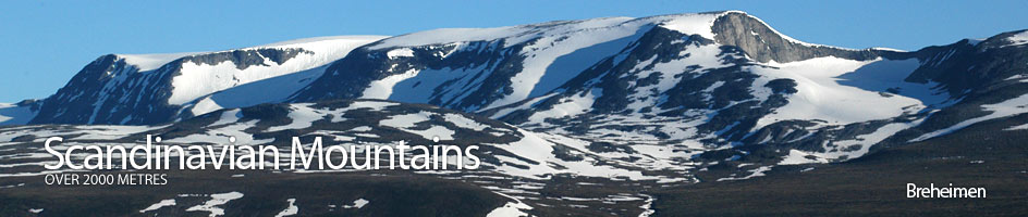
Scandinavian Mountains over 2000 metres - James Baxter
Areas › Breheimen › 15.12 Vestre Holåtind (2039m)
Vestre Holåtind, 2039m, is the westerly of the three Holåtinds. The entire east side of Vestre Holåtind is covered in a large glacier that flows into a lake, calving icebergs as it melts to a halt. This glacier, and the saddle it has carved, separates Vestre Holåtind from Midtre Holåtind. Much of the north side is covered in the huge Gjelåbreen glacier. It is only the south ridge that affords any straightforward ascent without a glacier crossing.
| The Route from Trulsbu Cabin | |
|---|---|
      |
|
Leave Trulsbu cabin and head west up Vesldalen following the marked path across the flats, keeping on the north side of the stream. After about 1 km start to climb up for another one km and cross the stream near the top of the slope. This should bring you to the north edge of the Lake 1451m which the path skirts around. The path then goes slightly to the south of the western tip of the lake before it starts climbing a broad ridge for one km to pass on the north side of the small tarn marked 1589m. From here the marked but barely discernable path heads west up over snowfields and slabs to the top of the ridge by spot height 1698m.
It is not possible to pass to the east of Lake 1551m as the glacier flows into it calving icebergs, so a detour has to be made round the western side of this lake. So from the spot height 1698m continue west over snowfields and bare rock for ½ km until the route descends down a small valley towards a slight plateau with three tarns on the south side of Lake 1551m. Again the path on this section is only recognizable by the frequent and large cairns along it. The outflow from the Lake 1551m difficult to cross in the 10 metres from the lake until it plunges over a waterfall so it is best to descend still further to a lake at about 1498m. It should be easy to cross here between the waterfall and the lake.
After crossing the river head north back up the scree of the valley side and pass on the east side of knoll 1672m, keeping a short distance to the edge of Lake 1551m. After about 1 km you arrive at some small tarns at the bottom of the south ridge of Vestre Holåtind. Cross the moraine debris and start heading north up to the ridge itself. The ridge is largely composed of stable boulders covered in black lichen and is easy in dry weather and safe but slippery in the wet. After 1½ km from the tarns the ridge starts to level out and the summit is one km away across a gently sloping plateau. The view from this summit is particularly impressive; to the east are the other two Holåtinds and the huge glaciers that flank them while to the south are the lofty massifs of Smørstabb and Hurrungane which rises above the deep canyon of the Fortundalen valley. To the west is the largest ice cap in Europe, Josterdalsbreen, topped by Lodalskåpa, 2083m.
The return is by the same route to Trulsbu cabin. If the return is being made to Sota seter descend down the south ridge for about a half km, then head west down the steepish slope to the Stillgrovi stream. Cross this stream and continue west, then north west contouring round the southern slopes of Hill 1857m and knoll 1629m for about three km until the stream coming down from Tundradalsbandet pass is met, ideally at about 1420 metre elevation. Here the marked path from Sota seter to Nørdstedalsæter should be intercepted, but it is still a further three hours to Sota seter. Cross the stream and follow the cairns in a north west direction for one km up the boulder covered slope passing to the west of knoll 1635m. The path now continues north west across a level wastescape of large moraine and icy tarns for one km. At the end of this level section it continues to climb slightly and crosses a 400m wide glacier which has no crevasses at this altitude of 1630 metres. At the far end of the glacier the path reaches its highest point and heads down across easier boulders for two km to the western point of Lake Sottjørnin. After an easy one km climb over a shallow ridge to the north by knoll 1532m the path begins the long 800m over four km descent to Sota seter which is now in sight and just over an hour away. This descent is made all the more pleasant as the moraine and boulders which have been present since Trulsbu cabin at last give way to grassy slopes and the fertile birch, then pine forests of the idyllic Bråtådalen valley and the charming Sota seter lodge.