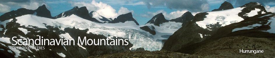
Scandinavian Mountains over 2000 metres - James Baxter
Areas › Hurrungane › Storen › Alternative Routes
There are now many routes to the summit, some of exceptional quality, but all require climbing. The original route, Slingsbys' route, is now seldom used because the glacier, Slingsbybrean, can cause difficulties. The easiest route via Andrews' renne is grade IV, however, there is a danger for stone and rock fall from the scree filled gully above.
 The most popular route is Heftyes' renne which is a grade V for the 4 metre crux and otherwise offers some marvellous grade III climbing for its 2 rope lengths. The most common descent is a 55 m abseil back to the an area called the Hjørnet which is where Heftyes renne route starts.
The route I recommend and describe below is Heftyes renne and the 55m abseil. The only drawback is that as the season is short the route might be busy during periods of settled weather during late July to early August.
The original route, Slingsbys' route, goes up from Turtagrø to Skagastølsbu shelter. From here it follows the km shelf under the south face called Berges chausée to Slingsbybrean and then it climbs the very variable glacier to Mohns skar saddle, as described on the Sentraltind page.
From Mohns skar the route climbs up the north east ridge, with a pitch of grade III, to the summit as described below in the Skagastøls ridge traverse explanation.
Skagastøls Ridge Route
A classic, but much more demanding ascent, is via the entire Skagastøls ridge. This again starts from Turtagrø hotel and goes over the peaks Nordre Skagastølstind, Skagastølsnebbet, Midtre Skagastølstind and Vesle Skagastølstind before reaching Mohns skar and then climbing up the north east ridge of Storen.
Follow the route Hu.8 up Skardstølsdalen to the Tindeklubhytta cabin as described in the recommended section below. Once at this cabin leave the track and head up the side valley to the east. The grass slopes soon give way to stones as you ascend towards a saddle with a lake at 1584m. Before you reach the west end of the lake leave this stony valley and start to clamber up the ridge to the south east.
This relentless ridge ascends over 600 metres quite steeply up unpleasant boulder fields to the top of Nordre Skagastølstind. From here there is a initially a steep descent to the south towards Nebbskar, the saddle with Skagastølsnebbet, but this soon eases off, and the ascent up to Skagastølsnebbet is quite straightforward with a couple of sections with easy scrambling towards the top.
From the top of Skagastølsnebbet however the going get more serious. Initially there is a steep 35 metre scramble down into a deep notch called V-skaret. From the bottom of V-skaret there is a 40 metre 2 pitch climb to ascend the south side. The lower pitch is 20 metres and is a grade IV climb while the upper pitch is 20 metres of exposed grade III. There is a good stance between the pitches.
 At the top of this climb there are some shallow slabs which lead to a small flat area called "Berges stol". From Berges stol the arête narrows and steeply rises for another 30 metres of grade III climbing to the exposed top of Midtre Skagastølstind.
After Midtre Skagastølstind the arête continues south to Vetle Skagastølstind. This section, which is arguably the finest of the whole traverse, begins with a short exposed descent down the arête until it levels off after 25 metres.
Then comes a tricky down climb which is a good grade III for 10 metres and where most people will feel more comfortable abseiling. After the abseil the arête becomes even sharper and narrower and it is necessary to creep along one very thin 10 metre section, before it broadens out again. From this narrowest section the arête is largely horizontal for 300 interesting metres to the foot of Halls hammer. During this level section there are a number of short interesting scrambles to overcome to reach Halls hammer.
Halls hammer itself is a vertical 15 metre crag with 2 vertical cracks each of which are grade VII. However, the ascent of it can be avoided by making a short detour to the east of the crag and crossing a slab called "Patchells sva". After Patchells sva there is a short boulder filled corner which climbs for 10 metres to gain the arête again, just above Halls hammer. This detour is grade IV. From the top of Halls hammer the arête continues south but now starts to climb up to Vetle Skagastølstind, where there are again numerous short grade III scrambling sections.
 From Vetle Skagastølstind there is a choice of descending the south ridge to Mohns skar or descending the east ridge to the saddle with Sentraltind and then clambering across self formations on the south face of Vetle Skagastølstind to Mohns skar. The south ridge is shorter but involves two 25 metre abseils down its steep apex.
If coming the other way the south ridge of Vetle Skagastølstind is grade IV for a lower pitch and grade V for the upper pitch before the top. The east ridge is relatively easy with some short scrambling sections down to the saddle. From here it can be difficult to find the right place to begin the traverse across the south face of Vetle Skagastølstind, as the shelf formations are not so obvious here. In addition to this there could be some lingering snow patches, which are often icy. The best place to start the traverse is at the lowest point of the saddle but it is only after 50 metres of traversing across a grade III scramble that the shelves becomes more obvious. As you approach Mohns skar the shelves become wide and easy.
From Mohns skar the final hurdle of the north east ridge of Storen has to be overcome. This was also Slingsbys task late in the evening on 21 July 1876, when he made the first ascent and he had to do it solo while his two companions waited at the saddle. Initially the route goes up the arête and then veers to the west side of it for a grade III section about ½ way up after 100 metres, which most choose to abseil if descending.
From this point the route now regains the crest and continues up it veering slightly to the east side before reaching the false summit called "Slingsbys fortopp", where there is a short airy walk across the roof of Hurrungane to the main summit. The total time from Turtagrø to the summit is about 9-11 hours.
The Return
The return can either be by the descent route given below involving the 55 abseil to the Hjørnet and then to Skagastølsbu shelter and Turtagrø or back to Mohns skar and down Slingsbybrean to Skagastølsbu shelter and Turtagrø as described on the Sentraltind page. Either descent is likely to take 5-7 hours.
Alternatively it is possible to return to Mohns skar and then continue along Styggedals ridge to Gjertvasstind and Skogadalsbøen lodge but this will take 9-12 hours and will necessitate a nights bivouac on the ridge. If doing this greater traverse it is normal to do it the other way round from east to west, doing the Styggedals ridge first and then descending the Skagastøls ridge on the second day. For further details on this greater traverse see the Sentraltind, Styggedalstind and Gjertvasstind pages.