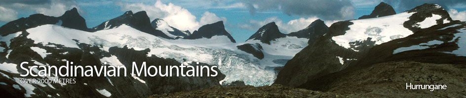
Scandinavian Mountains over 2000 metres - James Baxter
Areas › Hurrungane › 1.7 Store Ringstind (2124m)
Store Ringstind, 2124m, is one of the most characteristic mountains in Norway. Almost vertical on 3 sides, while the fourth side is a 35-40 degree slope covered in a glacier it looks like a huge wedge. This profile has inspired the architecture of the modern Turtagrø hotel. This glacier is covered in crevasses and in the summer, some may extend across its entire width. However, Store Ringstind is also an exceptionally good mountain for a spring ski ascent, particularly in early May, when most of the difficulties caused by the crevasses have yet to appear.
| The Route from Turtagrø Hotel | |
|---|---|
      |
|
From Turtagrø drive the 3 km on the small road to Årdal, until there is a small rough gravel road heading south up Ringsdalen for ½ km. Park somewhere here and head down to the river and cross the dam and pick up the path on the east side. This path follows the river for 3 km across pleasant level meadows with the spectacular view of Store and Midtre Ringstind at the end. After 3 km the path reaches a braided gravel bed in the river and shortly afterwards leaves the meadow and enters a boulder field. Continue through this boulder field for a further km until you reach a small lake.
 After this lake you are surrounded by moraine but the boulder field on the west (right) is actually sitting on top of the melting snout of the glacier. Follow the edge of the glacier for another km through more boulders until the going gets easier and the rocks smaller. From here, in the summer, two snowfields should be visible below cliffs on the east side of the valley. One with waterfalls beside it and the other further north without waterfalls. It is the latter one to now aim for, up a scree covered slope.
This snowfield varies in size according to how the previous winters snowfall has been and the time of summer. It needs to be ascended. If the snowfield has melted to the extent a rock band is exposed at the top, then it is perhaps easiest to ascend the snowfield directly and then climb out of the steeper rock band at the top on the southern side. The climb up the rock band is steep and wet and is grade II.
 From the top of this snowfield or rock band the route descends slightly southeast for a ½ km across a flatter moraine area until you reach the edge of the glacier. On the return journey do not head down to quickly to find the route down the rock band and snowfield as it is surprisingly far to the north. The route is marked by cairns.
Due to the glacial environs of Store and Midtre Ringstind it is not possible to do these mountains solo during the late spring and summer time. Indeed parties should not only have glacial experience and equipment, but also some rescue knowledge and pulleys to carry out any crevasse rescue. At the edge of the glacier you should prepare for this glacier travel.
Initially the route is towards Ringsskard saddle to the south but eventually slowly starts to swing round to the southwest so as to pass the lower edge of the glacier directly north of Midtre Ringstind. While crossing this part of the glacier you should pay extra special attention to stones rolling down from the steeper glacier from above, especially on a warm or wet day, and it is unwise whatever the weather to pause here. Once this section of the glacier is passed continue in a southwest direction passing above a icefall to reach the flatter saddle between Store and Midtre Ringstind. This saddle is called Gravdalskard and contains many crevasses.
 From Gravdalskard the route follows the glacier that comes down from Store Ringstind. In general it is slightly easier to find a route up the middle to south of the glacier but this depends on the time of year. About ½ way up there is often a particularly large crevasse that might stretch across the whole glacier during the late summer. Normally, the last snow bridge disappears on the very southern side. It is usually obvious to see this from further down. If this bridge has gone then it will be necessary to climb onto the rock ridge also on the south of the glacier and bypass the crevasse. This may not always be an easy transition due to a varying bergschrund.
After this large crevasse the gradient eases and the route continues up the glacier heading for a midpoint on the summit ridge. As the summit ridge approaches the gradient steepens again and the snowfield on the glaciers' surface will invariably give way to blue ice, which maybe as much as 45 degrees. A couple of ice screws could be useful here.
Beyond the blue ice at the top of the glacier is the summit ridge. Late in the summer season the top of the glacier may have melted sufficiently to expose a large amount of very loose stones between the top of the blue ice and the summit ridge. Care should be taken here not to shower you partners with rocks. Once on the ridge it is an easy, but quite airy short trip south along the summit ridge to the top.
 The view from the summit is magnificent. Store Skagastølstind to the north-east has a wonderful symmetry with the Skagastøls ridge on the left and the Styggedals ridge on the right. Particularly impressive also is Austanbotntind to the south-west with is fearsome cliffs.
The Return
The return is by the same route. It should be easily possible to combine an ascent of Store Ringstind with an ascent of Midtre Ringstind in the summer from the heavily crevassed Gravdalskard saddle between them. If ascending Midtre Ringstind also, allow an extra 2½ hours. For more details see the Midtre Ringstind page.
Perhaps the best time to ascend Store Ringstind is in middle spring during the last ½ of April and the first ½ of May. The problems of the summer, i.e. the steep wet rock band, the extensive crevasses, and the steep blue ice and loose scree just before the summit are significantly diminished. The last 300m are too steep to ascend on skis and these are normally left, while the final section is done on foot. The descent is truly magnificent, but some sections are quite steep.