Scandinavian Mountains over 2000 metres - James Baxter
Areas › Stølsnos Massif › Detailed Information
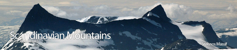
The Stølsnos Massif is a small compact massif in the south west of the rugged Jotunheimen. It only contains three mountains and these three can all be combined into a long summers day. The massif is bounded by deep valleys caused by powerful glaciation on all sides. The glaciers in these valleys have now gone but the higher flanks of the massif are still covered in glaciers on virtually all sides. None of the mountains are suited for winter ascents because the ascent routes are avalanche prone and steep.
Falketind
Falketind is the best known of the three mountains in the massif if not one of the best known mountains in Norway. This is in part due to its remarkable profile and partly due to its association with the renowned Norwegian poet and naturalist Åsmund Vinje who spend many summers at Eidsbugården in the middle of the nineteenth century.
Falketind was also one of the first of the more challenging 2000 metre mountains to be climbed in Norway in 1820, which was surprisingly early given the remoteness and terrain.
Utledalen Valley
On the west side of Stølsnos Massif is the huge ½ km deep canyon of Utledalen Valley. There are a few steep paths out of this valley onto the flatter mantle between the valley and the massif. These paths are very steep and seldom used in the winter and spring but in the summer time they are used to access the collections of historic summer farms and tourist cabins situated on this mantle. The mantle is too high to be used for any cultivation and was essentially a summer pasture for the animals.
Most of the summer farms have been restored and some are now used by walkers. Previously the forest on this mantle were harvested for timber. The logs were floated over the Vettisfossen waterfall in the spring when their impact after a 200 metre freefall was reduced by a huge cone of ice which remained from the winter at the bottom of the falls. Normally the falls are 273 metres.
Tyin and Bygdin Lakes
To the east of the massif lies the wilds of Jotunheimen and the two big lakes Tyin and Bygdin which make the southern boundary of this mountainous region. Historically this region remained the domain of hardy reindeer hunters until the middle of the nineteenth century when Vinje and friends arrived at Eidsbugården and DNT up it first tourist cabin on the east shore of Tyin lake in 1870.
Morka-Koldedalen Valley
To the south of the massif is the deep Morka-Koldedalen valley, one of the most classic U shaped valleys in Jotunheimen. This steep sided valley boasts Falketind on one side and Hjelledalstind on the other. Between these mountains a remote and difficult lake blocks access for all but experienced walkers.